How Maps Were Born from Clay, Curiosity and Sheer Guesswork
Maps started long before paper, compasses or anyone arguing about whether north should point up. Someone in a prehistoric cave probably drew a squiggle on a rock to show where the good berries grew, and another person nodded very confidently while not understanding a single dot. That was humanity’s first flirtation with cartography. It wasn’t glamorous, but it set the tone: maps have always been half‑useful, half‑wishful, and entirely shaped by the people who draw them.
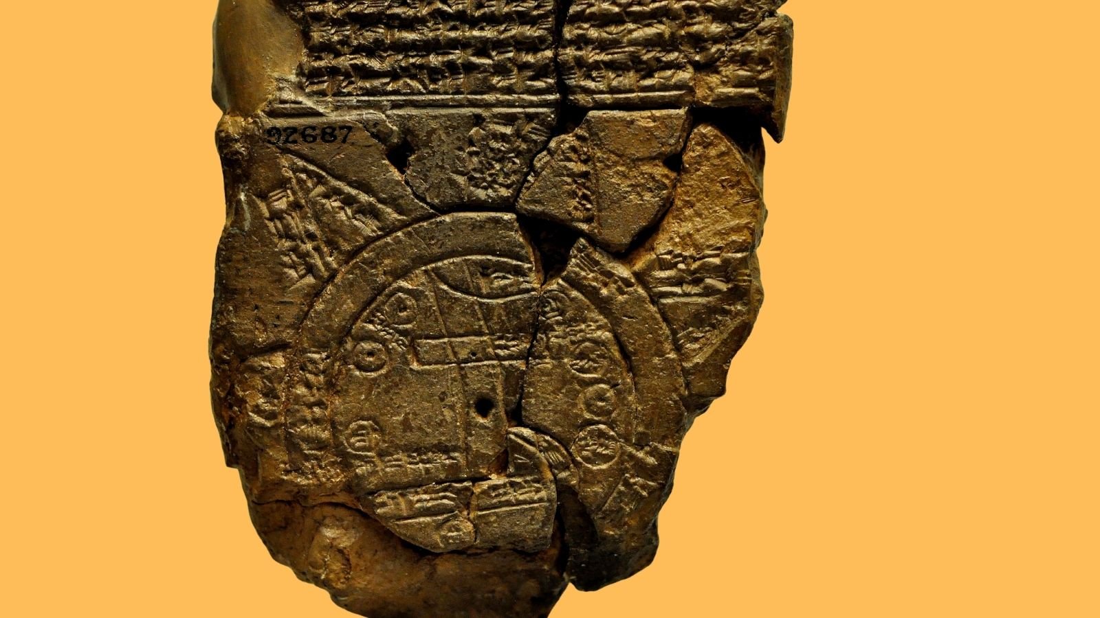
Human beings tried for millennia to make sense of space using whatever tools they had. Clay tablets, animal hides, bits of bone, bark, sand, anything flat enough to hold an idea. Early maps rarely resembled the world; they resembled what people believed the world should look like. There’s something touching about that. Imagine standing in ancient Mesopotamia, squinting at a lump of clay engraved with little scratches, being told with full authority that this is your neighbour’s field boundary, and also that the river definitely flows in exactly this shape. You accepted it because the person with the clay tablet said so, and also because disputing it meant paperwork, and early paperwork was carved in stone.
By around 600 BC, the Babylonians produced what we now flatteringly call the world’s oldest surviving world map. It’s a palm‑sized clay tablet showing Babylon in the middle of everything, surrounded by a neat circle of ocean. If you ever needed proof that people always place themselves at the centre of the universe, there it is. Anyone inspecting that tablet today can spot the creative liberties: rivers doing improbable loops, mountains placed suspiciously close together, distant lands reduced to vague triangles labelled with something like ‘beyond here be misery’. But the idea was bold. The map suggested you could hold the whole world in your hand, even if the world in question looked a bit like a forgotten biscuit.
The Greeks later approached mapping with the confidence of people who had just invented philosophy and thought they could also sort out geography before lunchtime. They didn’t always succeed, but the ambition was impressive. Figures such as Anaximander tried to sketch the known world, while others speculated wildly about its shape. Some pictured the earth as a cylinder, others as a sphere, and still others decided it was flat but not too flat. Mapmaking became a game of intellectual one‑upmanship, where each scholar tried to out‑clever the last by adding an extra sea or adjusting the size of India.
Then came Claudius Ptolemy, a man who treated cartography as a personal challenge. Living in the second century CE, he wrote a multi‑volume manual explaining how to map the world using coordinates. Latitude, longitude, grids, the whole mathematical toolkit. Suddenly, maps didn’t have to rely on vibes. They could be measured, reasoned, argued about using numbers instead of spears. Ptolemy offered a system that let people imagine places they’d never seen, and sometimes never would. His maps weren’t perfect, but perfection wasn’t the point. He showed that you could model the world even when the world stubbornly refused to sit still.
Across the centuries, mapmaking became a kind of cultural mirror. Medieval Europe filled its maps with theology, saints, monsters, and moral warnings. A mappa mundi from the Middle Ages could show Jerusalem at the centre, Africa buzzing with mythological beasts, and the edge of the world inhabited by people with enormous ears functioning as parasols. These maps weren’t meant for navigation. They were meant for storytelling. Travelling with one would have been as helpful as navigating with a newspaper cartoon.
Meanwhile, sailors quietly saved civilisation by demanding maps that were actually useful. Maritime charts emerged across the Mediterranean, showing coastlines, ports and prevailing winds. The famous portolan charts of the 13th century looked shockingly modern compared to other maps of their time. They ignored theological speculation and focused on the immediate: where the land stops, where the sea begins, how not to die on the way to Sicily. They had neat compass lines radiating across the page—useful, elegant and entirely indifferent to theoretical geography.
Of course, people still argued. The earth’s shape kept causing problems. Projection became the cartographer’s eternal headache. You try drawing a sphere on a flat surface and see how long it takes before something stretches like pizza dough. That’s how we ended up with the Mercator projection in the 16th century. It preserved directions perfectly for sailors, which was helpful. It also made Greenland look roughly the size of Africa, which was less helpful and continues to fuel pub arguments today.
When Europeans began crossing oceans more aggressively, their maps took on a new tone: part scientific endeavour, part political advertisement. Charts became tools of empire. Planting a flag on a coastline meant little without a map to prove it. Explorers returned home with sketches of islands, rivers and coastlines that often bore little resemblance to reality but were convincing enough for monarchs with ambitious budgets. Maps shaped claims, negotiations and future conflicts. A badly drawn river could trigger a territorial dispute lasting centuries.
Then printing arrived and turned maps into everyday items. What was once an elite skill suddenly entered households, classrooms, and the pockets of travellers. Maps became affordable, replicable, and decorated with flourishes to appeal to buyers. You could hang a map on your wall to show you were worldly or at least pretending to be. Cartographers added sea monsters for flair, probably to distract from the fact that no one had checked whether Patagonia was really that wiggly.
As science expanded, cartography did too. Land surveying became a serious profession. Triangulation networks mapped entire countries with astonishing precision. In the 18th and 19th centuries, many nations embarked on grand surveying projects, sending hardy souls to measure everything from mountains to muddy lanes. The results transformed administration, taxation, military planning and even national identity. A detailed map can unify a country far faster than a speech.
Meanwhile, people kept pushing the edges of the known world. Arctic and Antarctic explorers, driven by equal parts curiosity and madness, charted regions where compasses misbehaved and frostbite lurked behind every snowdrift. Their sketches often froze before they did. These maps weren’t just geographic achievements—they were proof that humans refused to accept blank spaces. Whenever someone saw a white patch labelled ‘unknown’, they immediately wanted to go there, catch pneumonia and claim the place for their flag.
The 20th century brought two revolutions: aerial photography and satellites. Suddenly, maps didn’t have to rely on explorers’ tales or sailors’ estimates. Aircraft captured the shape of coastlines from above; satellites gave us crisp outlines of continents, forests and deserts. We finally saw the earth as it truly looked, which must have been slightly alarming to anyone who trusted medieval illustrations of sea dragons.
Digital mapping then arrived and finished the transformation. GPS turned maps from static pictures into real‑time companions. Instead of asking a stranger for directions and receiving a wave towards the horizon, you could watch a tiny arrow move along streets with surprising authority. People developed new relationships with maps—some healthy, some not. Many trust the blue dot even when it tells them to walk straight into a river. Others use digital maps to discover hidden alleyways, odd cafés and unexpected corners of cities that paper maps never bothered to record.
But even today, maps remain imperfect. Every map makes choices: what to include, what to omit, what to emphasise. Maps present power as much as geography. A country’s border looks firm on paper, even when it’s contested on the ground. A city’s layout looks tidy from above, even when traffic suggests otherwise. The illusion of order is part of the charm.
Modern maps still carry traces of their ancestors. They reflect curiosity, ambition, bias, hope, and a touch of imagination. A map doesn’t just show you where things are. It shows you how someone wanted the world to appear. It’s the closest humanity has ever come to holding space in its hands.
And despite thousands of years of progress, the core idea hasn’t changed: someone looks at the world, interprets it, and draws it in a way that might help someone else. Sometimes they draw mountains accurately. Sometimes they invent a creature with the head of a horse and the tail of a fish. Both attempts say something true about the people who made them. A map is always a story.
We travel today with phones that whisper directions in reassuring tones. We zoom in, zoom out, measure distances, plan journeys with absurd precision. Yet there’s still magic in unfolding a paper map, feeling the rustle, seeing the creases of all the places it has already visited. Paper maps age like travellers; digital maps update themselves and never develop character.
Still, whichever format you choose, you’re part of a tradition older than writing. When you follow a route, you’re joining every ancient wanderer who once scratched a diagram in the dirt to explain where the river bends. They’d probably be shocked by satellites, but they’d understand the impulse. They also wanted not to get lost.
So the invention of maps wasn’t a single moment. It was a long chain of people trying not to wander into a swamp. Humanity invented mapping the same way it invented storytelling—bit by bit, out of necessity, curiosity and the need to point confidently in a direction even when you weren’t entirely sure it was right.